
Believe it or not, this 2015 complete and epic image of the sunlit side of the earth is only the second such photograph since 1972. Taken from a million miles away, read on to see why it is only the second and to see the other previous images which were composites of multiple photos or “stitched” together.
Photos of Our Planet from Space
It has not been possible to capture images of the entire sunlit side of Earth all at once since Apollo 17 astronauts captured the iconic Blue Marble photograph in 1972 (shown further down in this post). While NASA has released other blue marble images over the years, these have been mosaics stitched together with image processing software — not a single view of Earth taken at one moment in time.
On February 11, 2015, DSCOVR was finally lofted into space and after a journey of about 1.6 million kilometers (1 million miles) to the L1 Lagrange Point, the satellite and its Earth Polychromatic Imaging Camera (EPIC) has returned its first view of the entire sunlit side of Earth. At L1—four times farther than the orbit of the Moon—the gravitational pull of the Sun and Earth cancel out, providing a stable orbit and a continuous view of Earth.
The image was made by combining information from EPIC’s red, green, and blue bands. (Bands are narrow regions of the electromagnetic spectrum to which a remote sensing instrument responds. When EPIC collects data, it takes a series of 10 images at different bands—from ultraviolet to near infrared.)
The Five Most Famous Images of The Earth
(in reverse chronological order)
2015

2005
In October 2005, NASA released a new version of the spectacular image collection that provides a full year’s worth of monthly observations with twice the level of detail as the original. The new collection is called the Blue Marble: Next Generation. Like the original, the Blue Marble: Next Generation is a mosaic of satellite data taken mostly from a NASA sensor called the Moderate Resolution Imaging Spectroradiometer (MODIS) that flies board NASA’s Terra and Aqua satellites

2002
In 2002, NASA produced The Blue Marble, the most detailed true-color image of the Earth’s surface ever produced. Using data from NASA’s Terra satellite, scientists and data visualizers stitched together four months of observations of the land surface, coastal oceans, sea ice, and clouds into a seamless, photo-like mosaic of every square kilometer (.386 square mile) of our planet.

2000

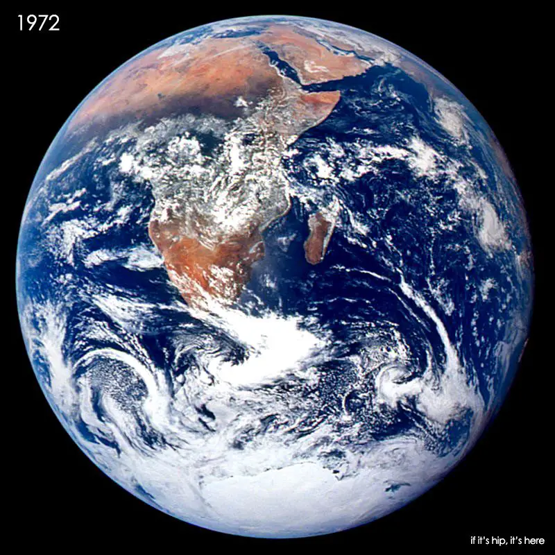
1972
This classic photograph of the Earth was taken on December 7, 1972. The original caption is reprinted below:
View of the Earth as seen by the Apollo 17 crew traveling toward the moon. This translunar coast photograph extends from the Mediterranean Sea area to the Antarctica south polar ice cap. This is the first time the Apollo trajectory made it possible to photograph the south polar ice cap. Note the heavy cloud cover in the Southern Hemisphere. Almost the entire coastline of Africa is clearly visible. The Arabian Peninsula can be seen at the northeastern edge of Africa. The large island off the coast of Africa is the Malagasy Republic. The Asian mainland is on the horizon toward the northeast.
all information and images courtesy of NASA